Port puzzler resolved
Council establishes new district along the river that puts ‘port in Port St. Lucie’
BY SUSAN BURGESS
“Where’s the ‘port’ in Port St. Lucie?” puzzled newcomers have asked since Port St. Lucie emerged from its status as a developer’s dream and crystallized into a city in 1961.
Truth be known, they probably wondered even before it was a city, when the Mackle Brothers were building what became Port St. Lucie. The Mackles’ successor, General Development Corp., had a penchant for starting developments all over the state with port in the name — never mind that they might be miles and miles from the nearest ocean.
The answer to the puzzled people was, of course, “There isn’t any port.” It was a marketing gimmick aimed at northerners who were so eager to buy a piece of Florida for $10 down and $10 a month that they just plunked their money down and ignored the misnomer that caught their eye in the first place.
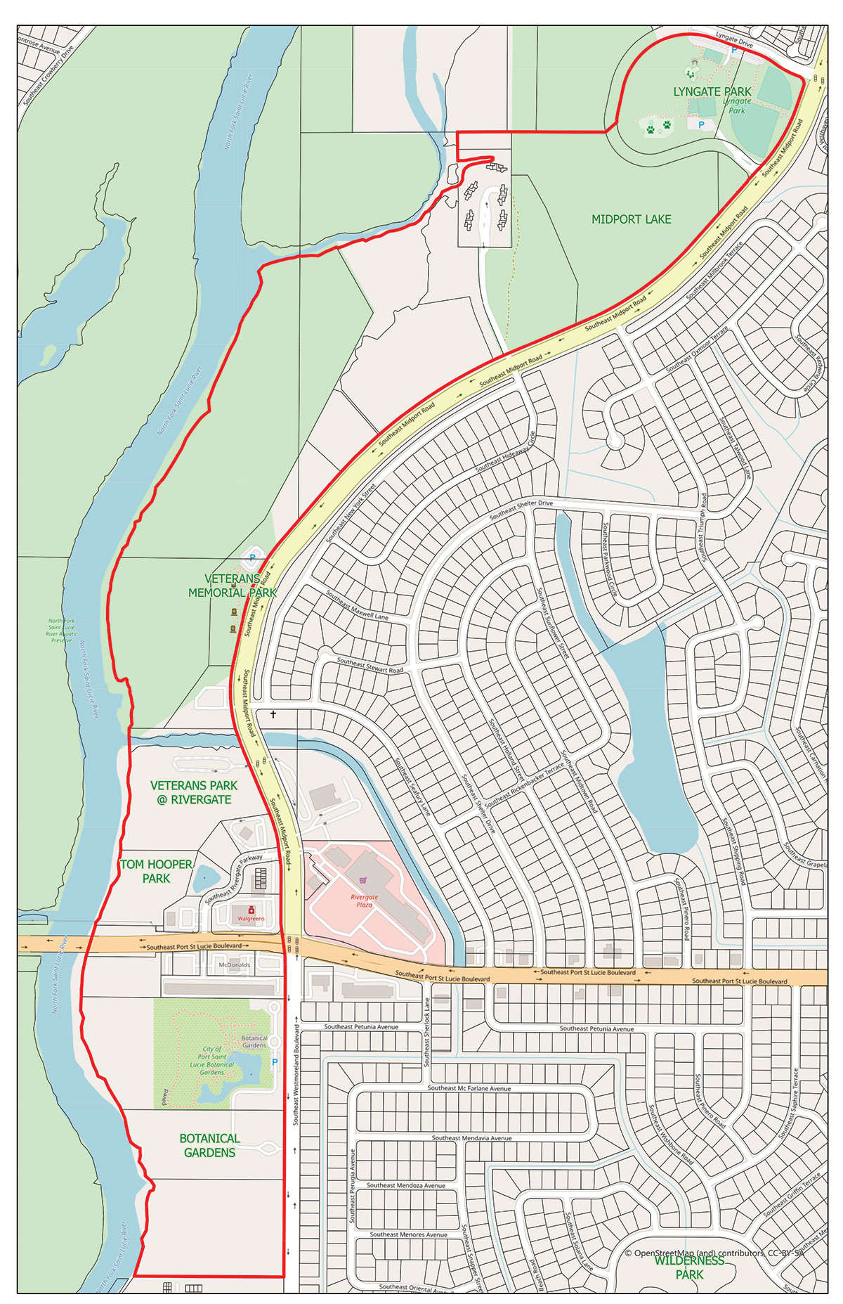
Ah! But now there is a port in Port St. Lucie. It’s just not the oceanfront type. The city council recently named a riverfront area The Port District after years of long-term planning. It’s an entertainment and recreation leg of land arranged along the scenic North Fork of the St. Lucie River designed to give residents and visitors more access to the waterfront.
“The city wanted to create a special place, a destination where people could enjoy multiple things,” said Councilwoman Jolien Caraballo, whose district includes The Port.
“With The Port District we’re putting the port in Port St. Lucie,” she said. “Culture, nature and fun is actually a goal of our strategic plan [for the future]. There’ve been definite requests over many years that people want to do things in their community.”
PLANS CHANGE
The idea of a destination for waterfront activities evolved over time.
“When I was first elected, in 2015, we talked about building houses [in part of what is now The Port District] and then the discussion kind of morphed into the idea of extending the Riverwalk [boardwalk] to the south,” she said.
That idea was a winner as it embodied the idea of nature and fun for residents and visitors alike.
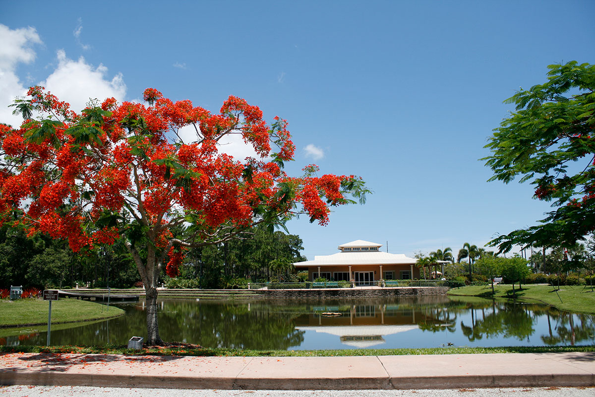
Starting at and including Lyngate Park, the district follows along Veterans Memorial Highway, crosses Port St. Lucie Boulevard and proceeds down Westmoreland Boulevard to the southern end of a city-owned parcel informally known as the Westmoreland Park, adjacent to the city’s botanical gardens. Veterans Memorial Highway becomes Westmoreland Boulevard when it crosses Port St. Lucie Boulevard.
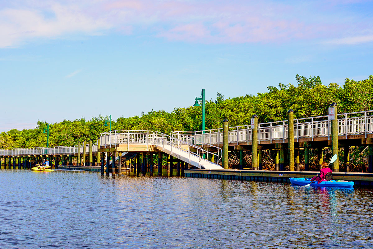
The newly named entertainment and recreation district is expected to serve as a hub for residents looking for something to do. Eventually it will include a restaurant, entertainment, a boat launch and much more. A boardwalk, built above the river, extends for about two-thirds of a mile along the shoreline from Rivergate to the conservation tract with a small 300-foot gap, which will be eliminated as soon as possible.
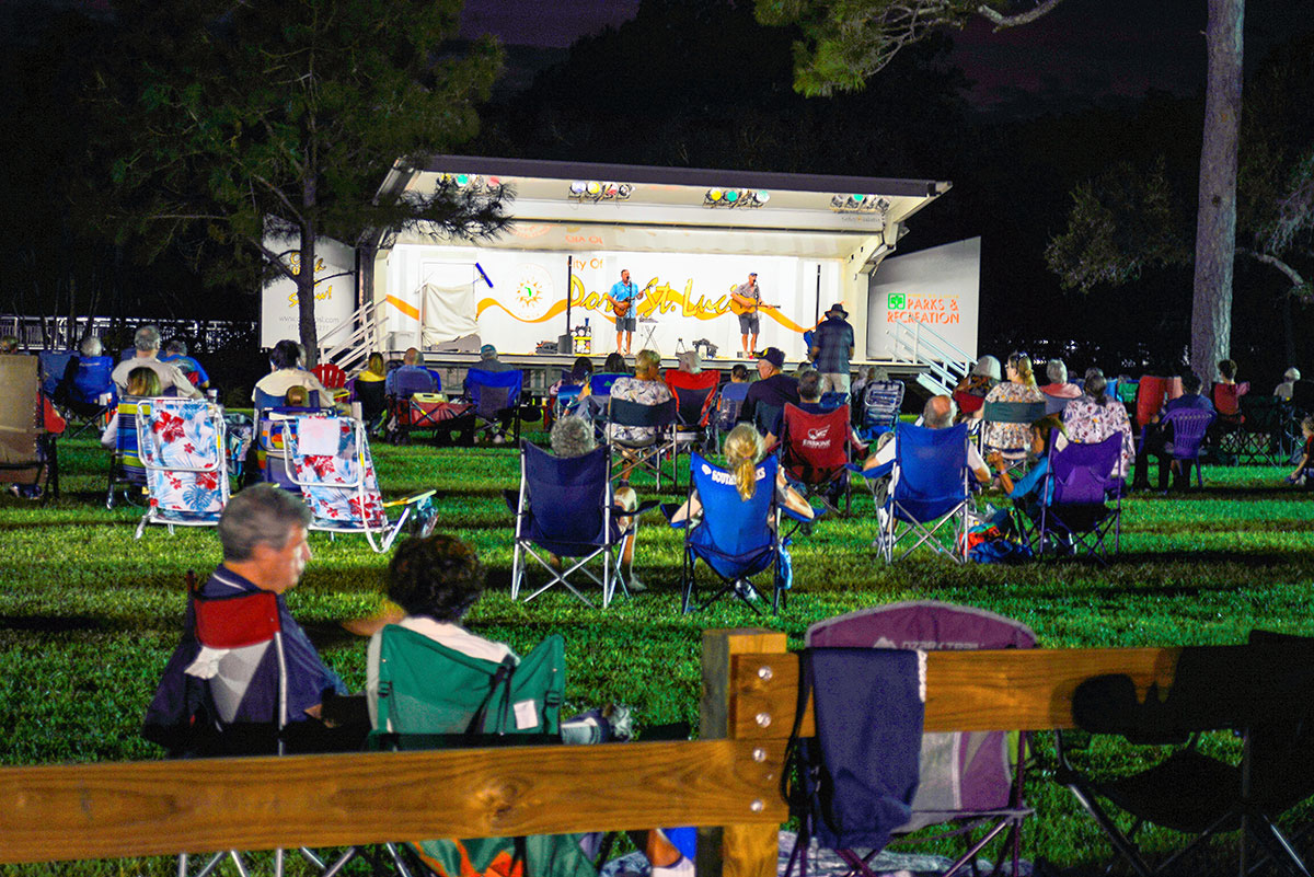
Plans for the northern end are just getting underway. But the southern end will include a 13-acre conservation tract with walking trails, an innovative custom-designed play park for children called Pioneer Park, a lawn for events such as River Nights and others, an historical village, boat docks and more.
One thing residents will have to get used to: The 10-acre park on Westmoreland adjacent to the botanical gardens, informally called Westmoreland Park, won’t have a name. Instead, its components will have names. The plan is to say Pioneer Park at The Port and Historical Village at The Port and Event Lawn at The Port. There’s no word on what features in the north end of The Port, almost two miles away, might be called since a new plan for it has not yet been created.
GOING BACK IN TIME
For more than 15 years before receiving its new designation as The Port, the district was known as Riverwalk North and Riverwalk South.
Riverwalk North and Riverwalk South appeared in Community Redevelopment Agency master plans as a mixed use area. The agency plans ways to repurpose land. In early plans, dating back to at least 2003, the northern end of the district was to include housing and retail along with recreational areas. A pond at that end is still popular with people who run remote-controlled boats and contains walking paths, Caraballo said.
The council recently hired a consultant to help plan for the entire Port District, approximately a mile and three-quarters in length. As is typically done in the city these days, citizens will have opportunities to say what they want to see in the new district.
But there was an even earlier iteration. Longtime residents will remember that a wooden boardwalk was built around 1983 along the water at Rivergate, just south of Veterans Memorial Park. Back then the road to it was called Midport Road, which was changed to Veterans Memorial Highway. River Nights, the relaxing once-a-month evening gatherings at the park on Westmoreland, got their start at Rivergate.
The new entertainment and recreation hub, or district, was a long time coming. Concept plans from the 1990s showed an area along the river called the Riverwalk, possibly during the tenure of Mayor Bob Minsky. Minsky was known for taking the lead on important projects, including the beginning of Crosstown Parkway.
In 2003, the city extended the wooden boardwalk from Rivergate southward along the North Fork and connected it to Tom Hooper Park near Port St. Lucie Boulevard. Visitors could go to Tom Hooper Park, park their cars and stroll along the boardwalk. In 2008, the wooden boardwalk was replaced with a sturdy structure that has an attractive surface for anyone who wants to walk, jog or enjoy the serene view of the river.
MORE HUBS TO COME?
A new leg of the boardwalk began to take shape in 2015 when money was allocated to create a new section from the bridge at Port St. Lucie Boulevard to the preservation tract at the southern end of the park on Westmoreland. It was completed in the fall of 2020. Next up is a short 300-foot connector that passes under Port St. Lucie Boulevard and attaches to the two boardwalks.
The Port is just one of several hubs the city council may be looking at for the future. At the council’s annual winter retreat in February 2020, the conversation turned to the need for such hubs, especially in the eastern part of the city. It’s long been said by council members that with western Port St. Lucie, including St. Lucie West and the entire area in and outside of Tradition growing rapidly and incorporating the very latest of amenities and features, residents who live in the eastern part have felt neglected.
“Since 2013, when we started strategic planning, we’ve talked about balancing the east and west side of the city,” Vice Mayor Shannon Martin said at the retreat.
Physical evidence of imbalance is there in the form of empty storefronts, Mayor Gregory Oravec noted during that meeting.
“So it’s completely fair that the city will have a draw to the eastern side,” Oravec said “But where the east side really has the advantage is that the city center ties into Riverwalk and Riverwalk should be one of the natural hubs of the city. And it could be so special.”
The Riverwalk district was renamed The Port months after that meeting.
The city center, a 46-acre parcel on U.S. 1 and Walton Road containing the city’s civic center [renamed the MIDFLORIDA Credit Union Event Center] is expected to become the hub of the city’s new mixed use downtown area. Veterans Memorial Highway is across U.S. 1 from the civic center and leads directly to the beginning of The Port District at Lyngate Park.
Across U.S. 1 and a little north of the city center is Village Green Drive, where planners hope to enhance the idea of a new downtown by adding businesses to the existing industrial uses that could include art galleries, retail shops, restaurants, craft brew houses and more, as a way to draw residents to the hub being created in the city center area. The next meeting for citizen input is Feb. 18 at 6 p.m. via Zoom.
What else might the council come up with to help the eastern side of the city “feel some love” as Councilwoman Caraballo put it? Time, the wishes of the residents, and the council, will tell.
See the original article in the print publication
FOR MORE INFORMATION …
Here are several links that can provide more details:
• The Port District Hub, including a look at the unique new Pioneer Park playground: https://tinyurl.com/ThePortDistrict
• See what citizens envisioned for the waterfront in 2015. Scroll to Page 53. https://tinyurl.com/Riverwalk2015
• City Center Hub: https://tinyurl.com/PSLCityCenter
• Village Green Drive Hub: https://tinyurl.com/VGDrive
• Community Redevelopment Agency or CRA plans: https://tinyurl.com/CommRedev
• Strategic Plan for the Future; these plans are updated quarterly: https://tinyurl.com/StratPln